Greetings, dear students, and a warm welcome to this exciting lesson about locating places on planet Earth!
Our team of expert teachers, educated both in India and overseas, has thoughtfully crafted these solutions just for you. Each and every concept has been explained in a lucid manner for easy retention. Remember, learning is a wonderful journey, and we’re here to guide and cheer you on every step of the way!
Find Solutions for NCERT Class 6 Social Science Exploring Society: India and Beyond Chapter 1 “Locating Places on the Earth,” here.
The Big Questions?
1. What is a map and how do we use it? What are its main components?
Answer:
A map is a drawing that shows a particular area, like a village, town, state, country, or even the whole world. It lets us see what the area looks like from above, making it easier to understand where things are located. We use maps to find our way, learn about different places, and understand how far things are located from each other.
There are different types of maps:
Physical maps show natural features like mountains, oceans, and rivers, plateaus, deserts etc.
Political maps show countries, states, boundaries, and cities.
Thematic maps focus on specific information, like weather patterns or population.
The main components of a map are:
Distance (Scale): Shows how much smaller the map is compared to the actual area.
Direction: Uses a compass rose to indicate North, South, East, and West.
Symbols: Represents different features on the map, like roads, rivers, or buildings.
2. What are coordinates? How can latitude and longitude be used to mark any location on the Earth?
Answer:
Coordinates are a set of numbers which help us find a particular location on the earth. These numbers identify a pair of latitude and longitude which locate the place.
Latitude measures how far north or south a location is from the Equator, while longitude measures how far east or west a location is from the Prime Meridian.
By using these two measurements or coordinates, any location on Earth can be precisely identified. For example, if we say “Delhi lies at 29°N latitude and 77°E longitude,” it means that Delhi is located 29 degrees north of the Equator and 77 degrees east of the Prime Meridian (these values are not exact, but rounded off).
The parallels of latitude and meridians of longitude together form a grid, which help us easily find any location on Earth.
3. How are local time and standard time related to longitude?
Answer:
Local time is determined by the position of the sun in the sky relative to a specific location. As the Earth rotates, different longitudes experience noon (when the sun is highest in the sky) at different times.
Standard time is a uniform time set for a particular region or country, usually based on the local time at a central meridian. Time zones are established based on longitudes, and standard time is used to avoid confusion caused by each location having its own local time.
Local time varies according to the longitude of a place but standard time is fixed.
LET’S EXPLORE (Page 9)
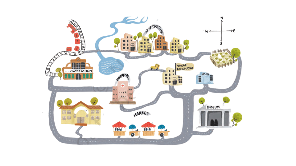
On the map in Fig. 1.1 given on page 8 —
1. Mark the hospital.
Answer:
It has been marked for you
2. What is the meaning of the blue-coloured areas?
Answer:
The blue coloured areas mark water bodies – a lake and a stream.
3. Which is farther away from the railway station — the school, the Nagar Panchayat or the public garden?
Answer:
The public garden is farthest away from the railway station.
As a class activity, form groups of three or four students each. Let each group try to draw a map of your school and some of the streets or roads that lead to it, and a few neighbouring buildings. At the end, compare all the maps and discuss.
Answer:
Do it yourself with the help of your teacher.
LET’S EXPLORE (Page 10)
Draw a simple map of a school’s playground. Let us assume it is a rectangle, 40 m in length and 30 m in width. Draw it precisely with your ruler on a scale of 1 cm = 10 m. Now measure the diagonal of the rectangle. How many centimetres do you get? Using the scale, calculate the real length of the playground’s diagonal, in metres.
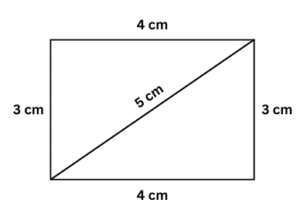
Answer:
The diagonal of the rectangle measures 5cm. Since the diagram is drawn on a scale of 1 cm = 10 m. the real length of the diagonal will be 5 x 10m = 50m
LET’S EXPLORE (Page 11)
Consider the map of the small city again. Identify the correct and incorrect statements in the list below:
1. The market is north of the hospital.
Answer:
Incorrect – The market is to the south of the hospital.
2. The museum is southeast of the bank.
Answer:
incorrect – The museum is to the south of the bank.
3. The railway station is northwest of the hospital.
Answer:
Correct
4. The lake is northwest of the apartment blocks.
Answer:
Incorrect – The lake is to the south west of the apartment blocks.
Taking your school as the starting point, do you know approximately in which cardinal direction your home is located? Discuss with your teacher and your parents.
Answer:
Do it with the help of your parents and teacher.
LET’S EXPLORE (Page 11)
Draw a rough map of your locality or your village, including your home, school and a few other important landmarks. Show the cardinal directions and use a few of the symbols shown in Fig. 1.2 on page 12 to mark some important features.
Answer:
Enjoy doing it yourself after discussing with your parents and teacher.
LET’S EXPLORE (Page 13)
Using the same terms, write down your move if you play black and respond with the same move.
Answer:
Playing black I move the queen’s pawn two steps forward from d7 to d5.
LET’S EXPLORE (Page 17)
If the globe or atlas in your class has well-marked latitudes and longitudes, try to note down approximate values for the latitude and longitude of (1) Mumbai, (2) Kolkata, (3) Singapore, (4) Paris
Answer:
Here are the approximate latitude and longitude values for the mentioned cities:
(1) Mumbai, India
Latitude: 19.05° N
Longitude: 72.85° E
(2) Kolkata, India
Latitude: 22.55° N
Longitude: 88.35° E
(3) Singapore
Latitude: 1.35° N
Longitude: 103.80° E
(4) Paris, France
Latitude: 48.85° N
Longitude: 2.35° E
LET’S EXPLORE (Page 21)
Two friends, one sitting in Porbandar (Gujarat) and the other in Tinsukia (Assam), are speaking on the phone late afternoon. The latter remarks that the sun has set in Assam and it’s now dark. The former is surprised and says, “But it’s still full daylight here!” Explain why. And, as a class activity, calculate the difference in local time between those two cities. (Hint: for now, consider the difference in longitude between Porbandar and Tinsukia to be 30°; later, you can find out the precise value.)
Answer:
Since Tinsukhia is situated east of Porbander, the local time in Tinsukhia is ahead of the local time of Porbander because the earth rotates on its axis from west to east.
Let us assume that the difference of longitude between Porbander and Tinsukhia is 300.
We know that the earth takes 24 hours to make one full rotation of 3600. So, it means that it takes 1 hour to turn 150 (360/24 = 15).
The difference in time between the two places which are 300 apart is ( 30/15) = 2 hours. The local time of Tinsukhia which is further east will be 2 hours ahead of the local time of Porbander. So, if the local time of Tinsukhia is 5pm, the local time of Porbander will be 3pm. Therefore, when the sun sets in Tinsukhia and dusk descends, there is still daylight in Porbander. Please note:
The longitude of Porbander (Gujarat) is 69.620E and the longitude of Tinsukhia (Assam) is 95.350E
LET’S EXPLORE (Page 21)
Return to the two friends sitting in Gujarat and Assam. Use this example to explain the difference between local time and standard time.
Answer:
The conversation about the difference in daylight between the two friends, one in Porbandar, Gujarat, and the other in Tinsukia, Assam, helps illustrate the concepts of local time and standard time.
Local Time:
Local time is the time based on the position of the sun in the sky at a particular location. It varies depending on the longitude of the place.
Since Tinsukia is located to the east of Porbandar, the sun rises and sets earlier in Tinsukia (because the earth rotates on its axis from west to east). Therefore, when it’s late afternoon and still daylight in Porbandar, the sun has already set in Tinsukia, and it’s dark there. This difference arises because local time is determined by the longitude of each location, and the Earth rotates 15° of longitude per hour.
In this example, the local time in Tinsukia is about 2 hours ahead of Porbandar because Tinsukia is located approximately 30° east of Porbandar. (30 /15= 2 hours).
Standard Time:
Since a country stretches across several longitudes, there will be different local times in different places in the country based on the longitude on which they are situated as we have seen in the case of Tinsukhia and Porbander.
This gives rise to practical problems, for example there will be difficulty in preparing a time table for trains which cross several longitudes.
So, it is necessary to adopt the local time of some central meridian of the country as the standard time for the entire country. In India the longitude 82 ½0 E is treated as the standard meridian. The local time at this meridian is taken as the standard time for the whole country. It is known as the Indian Standard Time (IST).
In this case, both friends, despite their different local times, would refer to the same standard time (IST) on their clocks. When it’s 6:00 PM IST, both Porbandar and Tinsukia clocks show 6:00 PM, but the position of the sun relative to the horizon differs (it has set in Tinsukhia but it is still shining in Porbander).
Questions, activities and projects (Page 24)
Questions, activities and projects (Page 24)
1. Returning to page 10 and to Fig. 5.2 in Chapter 5 of this textbook, taking the scale to be 2.5 cm = 500 km, calculate the real distance from the estuary of the Narmada River to the estuary of the Ganga River. (Hint: round off your measurement on the map to an easy number.)
Answer:
According to the online version of the textbook, the distance from the estuary of the Narmada River to the estuary of the Ganga River is taken as 10 cm.
Since the scale of the map is taken as 2.5 cm = 500 km, the real distance from the estuary of the Narmada River to the estuary of the Ganga River is (10 ÷ 2.5) x 500 km = 2000 km.
2. Why is it 5:30 pm in India when it is 12 pm or noon in London?
Answer:
India is located east of London at 82.300 E. As the earth rotates from west to east, the places to the east of London will be ahead of London time.
London follows Greenwich Mean Time (GMT) at 0° longitude.
India follows Indian Standard Time (IST), which is based on the 82.5° E longitude.
The Earth rotates 15° of longitude per hour. India is 5 hours and 30 minutes ahead of London because of the difference in their longitudes and the time zones they follow (82.5 /15 = 5.5 hours or 5hours 30 minutes).
That is why it is 5.30 p.m. in India when it is 12.00 noon in London.
3. Why do we need symbols and colours in the map?
Answer:
We need symbols and colours in maps because they make maps less cluttered and easier to read and understand.
Symbols represent different features on a map such as rivers, mountains, cities, roads, railway lines, post offices etc without crowding the map with too much text. They give us a quick visual reference to understand what each feature is. The Survey of India, a government body, has determined a set of symbols to be used for maps of India (or parts of India).
Colours help us easily tell apart different physical features like water bodies, mountains, forests, deserts and political boundaries which are all highlighted in different colours.
Symbols and colours together help to simplify complex information, making maps more useful and accessible for navigation.
4. Find out what you have in the eight directions from your home or school.
Answer:
Look around the surroundings of your school and spot landmarks in each of the eight directions. (Hint: Look for parks, hospitals, Banks, religious places, shops, shopping malls, markets, ponds, lakes etc). Discuss with your parents and teachers if you are not confident.
5. What is the difference between local time and standard time?
Discuss it in groups, with each group writing an answer in 100 to 150 words. Compare the answers.
Answer:
Group Discussion Task:
After discussing the points of difference between local time and standard time among students of your group, write the gist in 100 words. A sample answer has been provided for your reference:
Local time is determined by the sun’s position at a specific location, based on its longitude. We know that the Earth rotates 15° of longitude per hour from west to east, so the local time differs from one place to another. The local time of place A situated at 800E will be behind by one hour from the local time of place B situated at 950 E. If it is 12 noon in Place A, it will be 1 pm in Place B.
Standard time, on the other hand, is a uniform time followed across a region or country stretching across several longitudes, based on the time at a specific central longitude. This helps in maintaining consistency and avoiding confusion caused by varying local times. In India, the entire country follows Indian Standard Time (IST), based on the 82.5° E longitude, even though local solar times vary across regions.
Compare Answers:
After each group has written their answer, compare them to see how similar or different your explanations are. Discuss any unique perspectives or insights that emerged in your group’s discussion.
6. Delhi’s and Bengaluru’s latitudes are 29°N and 13°N; their longitudes are almost the same, 77°E. How much will be the difference in local time between the two cities?
Answer:
Since Delhi and Bengaluru are both located near longitude 770E, there will be no difference in local time between the two cities.
7. Mark the following statements as true or false; explain your answers with a sentence or two:
All parallels of latitude have the same length.
Answer:
False -Parallels of latitude decrease in length as you move away from the Equator towards the poles. The Equator is the longest parallel, while the poles are points.
The length of a meridian of longitude is half of that of the Equator.
Answer:
True – The length of a meridian of longitude is half of that of the Equator (assuming that the earth is a perfect sphere) since longitudes run only from the North Pole to the South Pole1, whereas the equator runs around the entire circumference of the earth.
The South Pole has a latitude of 90°S.
Answer:
True – The South Pole is located at 90°S latitude, which is the southern-most point on the Earth.
In Assam, the local time and the IST are identical.
Answer:
False – Local time in Assam is ahead of IST by about an hour, but IST is followed nationwide, so the clocks in Assam show the same time, even though the local time is different because the sun is in a different position.
Lines separating the time zones are identical with meridians of longitude.
Answer:
False – False. While time zones are generally based on meridians of longitude (15° apart), the actual boundaries of time zones can vary due to political and geographical factors, for example the International date lines zigzags to avoid splitting countries into different time zones.
The Equator is also a parallel of latitude.
Answer:
True – The Equator is the 0° parallel of latitude, and it divides the Earth into the Northern and Southern Hemispheres.
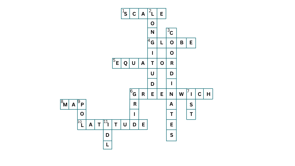
Crossword (Page 25)
1. Lets you squeeze a huge area into your map – SCALE
4. A convenient sphere – GLOBE
5. The longest parallel of latitude – EQUATOR
6. The place the Prime Meridian is attached to – GREENWICH
8. So convenient to find your way – MAP
10. A measure of the distance from the Equator – LATITUDE
Down
2. A measure of the distance from the Prime Meridian – LONGITUDE
3. These two together allow us to locate a place – COORDINATES
6. What latitudes and longitudes together create – GRID
7. The time we all follow in India- IST
9. These two are poles apart – POL
11. An abbreviation for a line across which the day and date change- IDL
Extra Questions for NCERT Class 6 Social Science 2024-2025 Exploring Society: India and Beyond Chapter 1 Locating Places on the Earth
A. Multiple Choice type Questions:
Choose the correct option
1. If you were to study the districts in your state what would you consult?
(i) a globe
(ii) a sketch
(iii) a plan
(iv) a map
2. Which map would show you how much rainfall different places receive?
(i) a physical map
(ii) a relief map
(iii) a thematic map
(iv) None of the above
3. If you wanted to locate the equator, the tropics and the poles, the Arctic and Antarctic circles, what would you consult?
(i) A globe
(ii) a thematic map
(iii)a relief map
(iv) None of the above
4. Which of the following is not a cardinal point?
(i) North-east
(ii) South -east
(iii) South-west
(iv) all of the above
5. The magnetic needle of a compass always points towards ____ direction.
(i) East-west
(ii) North-east
(iii)North-west
(iv) None of the above
Answer:
1. (iv) a map
2. (iii) a thematic map
3. (i) A globe
4. (iv) all of the above
5. (iv) None of the above
B. Fill in the blanks with suitable words from the box to complete the following sentences:
| maps | Atlas | intermediate | compass | cardinal points |
| universal | sketch | scales | political maps | north |
1. When many maps are put together we get an _______.
2. Maps showing cities, towns, villages, and different countries are called _________.
3. Maps are drawn to reduced ______.
4. The four major directions, North, South, East and West are called _____________.
5. We can find the direction of a place with the help of a ________.
6. Maps have a _________language that can be understood by all.
7. A _______is drawn mainly based on memory and spot observation and not to scale.
8. The three components of _____ are distance, direction and symbol.
9. The letter ‘N’ at the upper right hand corner of a map shows the _________.
10. We can locate any place more accurately with the help of __________directions.
Answer:
1. When many maps are put together we get an Atlas.
2. Maps showing cities, towns, villages, and different countries are called political maps.
3. Maps are drawn to reduced scales.
4. The four major directions, North, South, East and West are called cardinal points.
5. We can find the direction of a place with the help of a compass.
6. Maps have a universal language that can be understood by all.
7. A sketch is drawn mainly based on memory and spot observation and not to scale.
8. The three components of maps are distance, direction and symbol.
9. The letter ‘N’ at the upper right hand corner of a map shows the north direction.
10. We can locate any place more accurately with the help of intermediate directions.
C. Match the words in column A with those in column B
| A | B |
| brown | Water bodies |
| blue | Post office |
| green | plains |
| PO | Police station |
| PS | mountains |
Answer:
| A | B |
| brown | mountains |
| blue | Water bodies |
| green | plains |
| PO | Post office |
| PS | Police station |
D. State whether the following statements are TRUE or FALSE:
1. A globe can be useful when we want to study a part of the earth.
2. Physical maps show rainfall patterns across the world.
3. The three components of maps are – distance, direction and symbol.
4. The north-east is a cardinal point.
5. There is an international agreement regarding the use of symbols in maps.
6. Brown is used to show plateaus on a map.
7. A plan is a drawing of a small area on a large scale.
8. A compass is an instrument to find out main directions.
9. Most maps contain an arrow marked with the letter ‘N’ at the upper right corner.
10. Large scale maps give more information than small scale maps.
Answer:
1. False – A globe is useful when we want to study the earth as a whole.
2. False – Physical maps show natural features of the earth like mountains, plains, rivers.
3. True
4. False – The north east is an intermediate direction.
5. True
6. False – Brown is used to show mountains on a map. Yellow is used to represent plateaus.
7. True
8. True
9. True
10. True
E. Very Short Answer type Questions
1. What are the limitations of a globe?
Answer:
A globe is of limited help when we want to study only a part of the earth like our country, state, towns and villages.
2. What is a compilation of many maps called?
Answer:
A compilation of many maps is called an Atlas.
3. What do political maps represent?
Answer:
Political maps show cities, towns, villages, and different countries and states of the world with their boundaries.
4. What do thematic maps show?
Answer:
Thematic maps focus on specific information, such as road maps, rainfall maps, distribution of forests and industries.
5. What is a compass?
Answer:
A compass is an instrument used to find out main directions. Its magnetic needle always points towards north-south direction.
6. What are cardinal points?
Answer:
The four major directions: North, South, East and West are called cardinal points.
7. What is the North line?
Answer:
Usually most maps contain an arrow with the letter ‘N’ at the upper right-hand corner. The arrow points to the north so it is called the North line. It is important because when you know the North, you can find the other directions.
8. How can a compass guide us?
Answer:
We can find the direction of a place with the help of a compass. A compass shows us the main directions.
9. In which direction does the magnetic needle of a compass point?
Answer:
The magnetic needle of a compass always points towards the north-south direction.
10. What are conventional symbols?
Answer:
Maps have a universal language that can be understood by all. There is an international agreement regarding the use of symbols; they are called conventional symbols.
11. How do symbols help us to read a map?
Answer:
The conventional symbols which are universal help us read maps with ease. Even if we do not know the language of an area, the conventional symbols help us to identify the features shown on the map.
12. The scale of a map is given as 1 cm = 1km. What will be the actual distance of your school from your home if the distance on the map is 2cm?
Answer:
2 km
13. A man is looking for a house on the eastern fringe of the village. He is facing towards the North. Which way should he turn to reach the house?
Answer:
He should turn to his right.
14. Which colour represents plains on a map?
Answer:
Green represents plains on a map.
15. Which colour represents water bodies on a map?
Answer:
Blue represents water bodies on a map.
16. Which symbol would you use to represent a police station on a map?
Answer:
The symbol ‘PS’ would be used to represent a Police station on a map.
F. Short Answer Type Questions:
1. What is the difference between small scale maps and large scale maps?
Answer:
When large areas like continents or countries are to be represented on paper, then a small scale is used, that is 5cm on the map shows 500 km on the ground. Such a map is called a small scale map.
When a small area like a village is to be represented on paper, a large scale is used , that is 5cm on the map shows 500 metres on the ground. Such a map is called a large scale map.
Large scale maps provide more information than small scale maps.
2. Explain the difference between cardinal points and intermediate directions.
Answer:
There are four major directions, North, South, East and West which are called ‘cardinal points’.
In addition to these, there are four other intermediate directions lying between the cardinal points – north-east (NE), south-east (SE), south-west (SW) and North-west (NW) which are very helpful in locating any place with greater accuracy.
3. What is a sketch?
Answer:
A sketch is a drawing based mainly on memory and spot observation and not to scale. It is a rough drawing of an area to tell where a particular place is located with respect to other places.
Such a rough drawing is drawn without a scale and is called a sketch map.
4. What is a compass?
Answer:
A compass is an instrument which helps us find out the direction of a place. It is used to find out the main directions. It has a magnetic needle which always points towards the north-south direction.
5. What are symbols? Why are they used in maps?
Answer:
It is not possible to draw the actual size or shape of buildings, roads, bridges, trees, railway lines or a well on a map. So they are shown by using certain symbols like letters, colours, pictures and lines.
These symbols provide a lot of information within a limited space. The use of symbols makes maps simple and easy to draw and read.
There is an international agreement regarding the use of these symbols. That is why they are called conventional symbols.
6. How are colours used in maps?
Answer:
Various colours are used for representing different physical features on maps. For example, usually blue is used to represent water bodies, brown for mountains, yellow for plateaus, and green for plains.
G. Long answer Type Questions
1. What is a map? Describe different types of maps.
Answer:
A map is a representation of the earth’s surface or a part of it drawn on a flat surface according to a scale. Maps provide more information than a globe. There are different types of maps as discussed below:
(i) Physical Maps:
Maps showing natural features of the earth such as mountains, plateaus, plains, deserts, rivers, oceans are called physical or relief maps.
(ii) Political maps:
Maps showing cities, towns and villages, and different countries and states of the world with their boundaries are called political maps.
(iii) Thematic Maps:
Some maps focus on specific information, such as road maps, rainfall maps, distribution of forests, industries, agricultural crops etc are called thematic maps.
2. Discuss the three components of maps.
Answer:
The three main components of maps are: Distance, Direction and Symbol.
(i) Distance:
Maps are drawings which reduce the earth’s surface or part of it to fit on a sheet of paper. To achieve this, maps must be drawn to reduced scales. But this reduction has to be done very carefully so that the distance between the places is reflected accurately.
It can be possible if a small distance on the paper map represents a large distance on the ground. Therefore, a scale is chosen for this purpose.
Scale is the ratio between the actual distance on the ground and the distance shown on a map.
For example, the distance from your home to the hospital is 6 km. If you show the 6 km distance by 3cm on a map, it means that 1cm on the map shows 2km on the ground. The scale used in your map would be 1cm=2km.
So, we see that scale is very important in any map. If the scale is known, the distance between any two places on the map can be calculated with ease.
While drawing maps of large areas like continents or countries on paper, a small scale is used. For example, 2 cm on a map may show 200 km on the ground. This is called a small-scale map.
While drawing maps of a small area like a village or town, a large scale is used. For example, 2 cm on the map represents only 200 meters on the ground. This is called a large-scale map.
(ii) Direction:
Direction is a major component of any map. Most maps display an arrow marked with the letter ‘N’ at the upper right-hand corner. The arrow points in the north direction. It is called the north line. When the north is fixed, the other directions like south, east and west can be easily determined with reference to the North.
There are four directions North, South, east and west which are known as the cardinal points.
Moreover, there are four other intermediate directions which are: north-east (NE), south-east (SE), South-west (SW) and north-west (NW). These intermediate directions help us locate any place more accurately.
(iii) Symbol:
Symbols are the third important component of maps. It is impossible to draw on a map the actual shape and size of different features such as buildings, roads, bridges, trees, railway lines, mountains, or rivers. So, these features are shown by using certain letters, colours, pictures and lines which are called symbols.
Symbols give a lot of information in a limited space. They make both drawing and reading a map much simpler. Even if the language of an area is not known well enough to ask for directions, the symbols on the map provide reliable information about the area.
Maps have a universal language that can be understood by all because there is an international agreement regarding the use of these symbols. That is why they are called conventional symbols.
Colours are also used symbolically on maps. By convention the colour blue is used to show water bodies, brown to show mountains, yellow to show plateaus and green to show plains on maps.
Frequently Asked questions (FAQs) on NCERT Solutions for Class 6 Social Science Exploring Society: India and Beyond Chapter 1 Locating Places on the Earth
Our team of experienced subject experts, educated both in India and overseas, has thoughtfully crafted these solutions to ensure they are not only accurate but also engaging and easy to understand. Every concept is explained in a lucid and clear manner, making learning enjoyable and helping you grasp the material with ease.
We encourage you to dive into these solutions, as they’re designed to clarify all your doubts and strengthen your understanding of the lessons. You can download the free PDFs anytime for easy access!
And there’s even more on the way—exciting study material and helpful resources are coming soon! Keep visiting our website and don’t forget to join our email list to stay updated and gain free access to all the new content. Happy learning!
Yes indeed! You can download the free PDF versions of these excellent solutions anytime (please look towards the top of the page)!
Absolutely! Our dedicated team of skilled subject teachers has thoughtfully anticipated any questions you may have about the lesson and created these detailed solutions to guide you through every key point. They not only focus on the finer details but also capture the essence of the chapter, ensuring you gain a complete understanding.
We recommend starting by reading the lesson carefully, and then going through the solutions, paying attention to all the explanations. To deepen your learning, take a globe and locate important features like the Equator, the Poles, the Arctic and Antarctic Circles, the Prime Meridian, and the International Date Line. Notice how latitudes and longitudes intersect to form a grid, and challenge yourself by finding major cities using their coordinates. This hands-on activity will help you visualize the concepts and solidify your understanding.
Be sure to review the solutions before your exam, and take time to write out answers under timed conditions. This practice is key—not only will it help perfect your skills, but it will also boost your confidence, ensuring you’re ready to tackle any question that comes your way.
With a little practice, you’ll be ready to face any challenge. Good luck, and remember, we’re cheering for your success every step of the way!
Are you feeling overwhelmed by too many study options or unsure about where to start? You’re not alone! Many students face the same challenges, but the good news is, we’re here to help.
At educationroundtheworld.com, our expert teacher-mentors are dedicated to guiding you every step of the way. We understand how frustrating it can be to feel stuck or stressed. That’s why we offer personalized coaching tailored just for you. With our support, you can say goodbye to confusion and unnecessary pressure.
Here’s how it works: Simply reach out to us or book your first session now. From there, we’ll create a clear, stress-free plan that’s focused on your success. Imagine a study experience where you feel confident, empowered, and ready to reach your full potential!
The path to success is just one step away—take it with us today!