Greetings, dear students, and a warm welcome to an amazing analysis of this chapter on ‘Geographical Diversity of India”. Our team of expert teachers, educated both in India and overseas, has thoughtfully presented these solutions in a simple and interesting manner to ensure that you enjoy going through them. They have provided answers to all questions and activities in the chapter to guide you.
Remember, learning is a wonderful journey, and we’re here to guide and cheer you on every step of the way!
Need additional help? We provide top-quality coaching which will kindle your interest in social science and help you succeed in any exam! Contact us with your requirements anytime and we’ll be happy to help you out!
Find Solutions to NCERT Class 7 Social Science – Exploring Society: India and Beyond Chapter 1 ‘Geographical Diversity of India,’ here.
The Big Questions?
1. What are some key geographical features of India?
Answer:
India is a land of immense geographical diversity, featuring a wide range of natural landforms. Some of the key geographical features of India are:
Mountains: To the north lie the towering Himalayas, which not only act as a natural barrier but also influence the country’s climate. The Aravalli Hills in north-western India are among the oldest mountains in the world. The Garo, Khasi and Jaintia Hills lie in the North east and parts of this region experience some of the highest rainfall in the world.
Plains: The Indo-Gangetic plains, stretching across the north and east, are among the most fertile regions and support dense population and agriculture.
Plateaus: The central part of the country is dominated by the Deccan Plateau which forms part of the peninsular plateau. It is rich in minerals and home to several waterfalls like Jog Falls in Karnataka.
Deserts: To the west lies the hot and arid Thar Desert, while Ladakh is a cold desert where winter temperatures drop below –30°C.
Coastal Plains: The eastern and western coastal regions are lined with long coastlines and fertile deltas.
Islands: India is also home to several island groups, such as the Andaman and Nicobar Islands in the Bay of Bengal and the Lakshadweep Islands in the Arabian Sea.
Rivers: Mighty rivers like the Ganga, Brahmaputra, Narmada, and Godavari play a vital role in sustaining life across these regions.
This varied physical landscape makes India one of the most geographically diverse countries in the world.
2. How does India’s geographical diversity affect our lives?
Answer:
The diverse geography of India determines the livelihood of people and their interaction with their environment.
Agriculture is directly influenced by the type of land and climate of a place, for example, rice and wheat thrive in the plains, while the plateaus are known for cotton and millet. The availability of water from rivers and rainfall patterns differs across regions, affecting the type of irrigation and the choice of crops.
The natural resources found in mountains and plateaus contribute to industries like mining (mineral deposits), forestry (timber), and energy production, for example, waterfalls like Jog Falls are harnessed for generating hydroelectricity.
Coastal regions provide opportunities for occupations like fishing and serve as important hubs for commerce and transport.
Meanwhile, the picturesque mountain areas draw visitors from around the world, creating jobs in travel and tourism and horticulture.
The diversity in climate also bears a direct influence on cultural aspects such as language, food, clothing, and festivals, making each region unique.
Overall, the varied landscapes of India play a vital role in shaping the way people live, earn a living, and maintain their cultural traditions.
LET’S EXPLORE (Page 2)
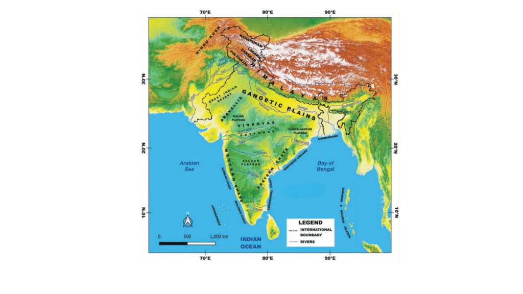
Look at the map of India at the end of this book. What are you able to observe? Recall your lesson on different types of landforms — mountains, plains and plateaus. Which landforms can you identify on the map? What do the different colours on the map mean? (Hint: The legend on the map shows the heights of each area.)
Answer:
When I look at the map of India at the end of the book, I notice that our country has many different landforms.
In the north, India is bounded by tall mountains called the Himalayas, which are coloured in brown on the map. These mountains act as natural borders and are the highest in the world.
Just below the Himalayas lies a vast flat green area, which is the northern plains. These plains are very fertile and good for farming because they are drained by many rivers.
In the west, the map shows a yellowish area — this is the Thar Desert, known for its dry land and sandy soil.
In the central and southern parts of India, I see the large peninsular plateau of which the Deccan plateau is a part. The plateaus are higher than the plains but not as high as the mountains.
The southern part of India is a peninsula, which means it is surrounded by water on three sides: the Arabian Sea to the west, the Indian Ocean to the south, and the Bay of Bengal to the east are coloured blue. The map uses different colours to show the height of land, and the legend helps in locating the rivers, and international boundaries.
Along the eastern and western coasts of India are the Eastern Ghats and Western Ghats, which are long, narrow hill ranges.
India is also home to many river systems, which include a main river and its smaller tributaries. These rivers are very important for drinking water, farming, and daily life.
There are two main types of river systems in India:
Himalayan Rivers:
These rivers rise in the Himalayas and flow throughout the year because they are fed by melting snow and rain. Major rivers include the Ganga, with tributaries like the Yamuna and Ghaghara, and the Brahmaputra, which flows through the northeast.
Peninsular Rivers:
These rivers start in the hills and plateaus of southern India. They mostly depend on rainfall, so some may dry up in summer. Important rivers include the Godavari, Krishna, Cauvery, Narmada, and Tapti. Most peninsular rivers flow into the Bay of Bengal, but the Narmada and Tapti flow into the Arabian Sea.
LET’S EXPLORE (Page 3)
Do you recall your lesson on latitudes and longitudes?
Answer:
Latitudes are horizontal lines around the earth that measure how far a place is north or south of the Equator.
Longitudes are vertical lines running from the North Pole to the South Pole that measure how far a place is east or west of the Prime Meridian.
These imaginary lines form a grid which helps us find the exact location of any place on Earth.
Look at the map. Can you read, approximately, the latitude and longitude where India lies?
Answer:
Looking at the map of India, I can read the latitude and longitude range of India approximately:
Latitude range of India:
India stretches roughly from 8° North to 37° North. (Exactly 8.4°North to 37.6°North)
Longitude range of India:
India extends from about 68° East to 97° East (Exactly from 68.7° East to 97.25°East)
So, India lies in the Northern and Eastern Hemispheres.
Identify the above features on India’s physical map.
Answer:
Using the physical map of India, you can spot the following:
Himalayas – In the north, along the borders with Nepal, Bhutan, and China.
Northern Plains – Just below the Himalayas, across states like Punjab, Uttar Pradesh, and Bihar.
Thar Desert – In the west, mainly in Rajasthan.
Deccan Plateau – Covers much of central and southern India.
Western Ghats – Along the western coast, near Kerala, Goa, and Maharashtra.
Eastern Ghats – Along the eastern coast, through Odisha and Andhra Pradesh.
Major rivers –
Ganga – Starts in the north and flows eastward into the Bay of Bengal.
Brahmaputra – Flows through the northeast.
Godavari, Krishna, Cauvery – Flow eastward in southern India into the Bay of Bengal.
Narmada and Tapi – Flow westward into the Arabian Sea.
LET’S REMEMBER (Page 4)
The Himalayas seem to touch the sky. In fact, many of its peaks are over 8000 metres in height and are together called the ‘Eight Thousanders’. This mountain range stretches across six countries in Asia: India, Nepal, Bhutan, China, Pakistan, and Afghanistan. Can you name the highest mountain in the world?
Answer:
Yes! The highest mountain in the world is Mount Everest. It stands at a height of 8,848.86 metres (29,031.7 feet). Mount Everest is part of the Himalayan Mountain range. It lies on the border between Nepal and the Tibet Autonomous Region of China.
Mount Everest is one of the famous ‘Eight Thousanders’—the group of 14 mountains in the world that are over 8,000 metres high, most of which are found in the Himalayas, for example Kanchenjunga (8586 m), Lhotse (8516 m). K2 (8611 m).
LET’S EXPLORE (Page 6)
Can you locate the names of the states in the different parts of the Himalayas? Take the help of both the physical and political maps for this exercise.
Answer:
The Himalayas stretch across the northern boundary of India and are divided into three main ranges—Himadri, Himachal, and Shivalik. These ranges pass through several Indian states, each home to different parts of the Himalayas:
The Himadri (Greater Himalayas) stretch through the northernmost parts of Jammu & Kashmir, Ladakh, Himachal Pradesh, Uttarakhand, and Sikkim. These areas are home to the highest peaks and glaciers, including parts of Mount Everest (on the Nepal border) and Kanchenjunga (in Sikkim).
The Himachal (Middle Himalayas) run across Himachal Pradesh, Uttarakhand, Sikkim, and parts of West Bengal and Arunachal Pradesh. These regions have pleasant weather and are known for popular hill towns such as Shimla, Mussoorie, and Darjeeling.
The Shivalik Hills (Outer Himalayas) extend through the foothills of Jammu & Kashmir, Himachal Pradesh, Uttarakhand, West Bengal, and Arunachal Pradesh. They gradually merge into the Northern Plains and support dense forests and wildlife.
DON’T MISS OUT (Page 11)
Most rivers are named after goddesses — Ganga, Yamuna, Kaveri, etc. The name of Brahmaputra, however, means ‘the son of Brahma’. This river gets bigger during summer instead of drying up! Can you guess why?
Answer:
Yes! The Brahmaputra River gets bigger during summer because it is fed by melting snow from the Himalayas and heavy monsoon rains.
During summer, the snow and glaciers in the Himalayas melt as temperatures soar.
At the same time, monsoon rains begin, especially in the northeastern region of India and in Tibet where the river originates.
Both the melting snow and rain add a lot of water to the river, making it wider, deeper, and faster during summer months.
LET’S EXPLORE (Page 11)
Notice the concentration of lighting in the plains. What could be the reason for this concentration?
Answer:
The concentration of lighting in the plains is due to denser population and greater development in those areas.
Plains (like the Northern Plains of India) have flat land and fertile soil, which makes them ideal for farming, building roads, cities, and infrastructure. These features attract more people to settle down in the plains compared to mountains and deserts where living conditions are harsher. The denser population means that there are more homes, schools, offices, industries and street lights. That is why when we look at a satellite image or a night image, the plains appear brighter as there is a higher concentration of lights.
LET’S EXPLORE (Page 12)
What is the shape of a sand dune? While mountains are made of rock and their shape is fixed, why do you think sand dunes also have a similar shape, even though they are made of sand?
Answer:
A sand dune may have a variety of shapes, for example a crescent, ridge, or hill-like shape with a gentle slope on one side (windward side) and a steeper slope on the other (leeward side). Crescent dunes are found in the Thar desert.
Sand dunes are made of loose sand, but their shape is created and maintained by the action of the wind. The wind transports sand grains across the desert, and when it slows down, the sand is deposited in low hill-like structures. This keeps happening, and over time, the sand forms a smooth hill-like shape. Even if the dunes move sometimes, their shape remains the same.
LET’S EXPLORE (Page 14)
Let’s go back to the map. Trace your path slowly from the Thar Desert towards the east. Do you see the Aravalli Hills?
Answer:
Yes, when I move eastward from the desert, I see a narrow range of hills running from southwest to northeast — these are the Aravalli Hills.
The Aravallis are one of the oldest mountain ranges in the world. They pass through Gujarat, Rajasthan, and continue into Haryana and Delhi,
The Aravalli Hills form a natural barrier which prevents the Thar desert from expanding eastward.
LET’S EXPLORE (Page 15)
Look at the political map in the textbook and identify the states that the range spans. Did you see Delhi, Rajasthan, Haryana and Gujarat?
Answer:
The Aravalli range extends through four Indian states: Gujarat, Rajasthan, Haryana, Delhi.
LET’S EXPLORE (Page 16)
Look at the physical map of India given at the end of the book. Notice the direction of the flow of the rivers.
Answer:
The Ganga and its tributaries flow from the north to the south east and drain into the Bay of Bengal. The Brahmaputra which is a tributary of the Ganga flows from the north east in a south westerly direction.
Most of the rivers of peninsular India – Mahanadi, Godavari, Krishna and Kaberi- flow from west to east and drain into the Bay of Bengal.
Only the rivers Narmada and Tapti flow from east to west across the plateau and drain into the Arabian sea.
LET’S EXPLORE (Page 17)
Tribal communities are largely spread over the states of Jharkhand, West Bengal, Odisha, Assam, Madhya Pradesh, Chhattisgarh, Maharashtra, Telangana, and Gujarat. Examine the physical and political maps at the end of this book to locate the states and connect them to their location on the physical map.
Answer:
By comparing the political map (state boundaries) and the physical map (landforms and forests) of India, we can see that tribal communities mostly prefer living in hilly, forested, or plateau areas — regions that are often harder to access but abound in natural resources.
States with large tribal communities and their physical features:
1. Jharkhand
Physical features: Hilly and forested.
Tribal Areas: Part of the Chota Nagpur Plateau.
This area is rich in minerals; many tribes like Santhals and Mundas live here.
2. West Bengal
Physical features: Eastern plains, western plateau which is part of the Chota Nagpur plateau, and hilly regions in the north.
Tribal Areas: Mostly in the western plateau and foothills of the Himalayas.
3. Odisha
Physical features: Coastal plains and Eastern Ghats.
Tribal Areas: Tribes live mostly in the hilly interior and forested areas.
4. Assam
Physical Features: Lies in the Brahmaputra valley, surrounded by hills.
Tribal areas: Tribal communities are found in the hills and along the river plains.
5. Madhya Pradesh
Physical Features: Plateau region with hills and forests.
Tribal Areas: Central India, part of the Vindhya and Satpura ranges.
6. Chhattisgarh
Physical Features: Mostly plateau and forest-covered.
Tribal Areas: Eastern part of MP; tribes live in the forests and hilly regions.
7. Maharashtra
Physical Features: Western Ghats and Deccan Plateau.
Tribal Areas: Tribal groups live in the hilly and forested areas, especially in the north and east.
8. Telangana
Physical Features: Part of the Deccan Plateau.
Tribal Areas: Found in hilly and forested parts, especially in the north and northeast.
9. Gujarat
Physical Features: Has hills in the east and coastal plains in the west.
Tribal Areas: Located mostly in the eastern hills and forests (e.g., Dang region).
LET’S EXPLORE (Page 19)
Look at the physical map of India in your school atlas or wall map and find the names of five rivers that flow into the Bay of Bengal.
Answer:
Five rivers which drain into the Bay of Bengal are:
Ganga, Mahanadi, Godavari, Krishna and Kaveri
Find out India’s coastal states and discuss the difference between the western and eastern coastal plains.
Answer:
India has a long coastline that stretches along the Arabian Sea (west) and the Bay of Bengal (east). The coastal states of India are:
The western coastal states (along the Arabian sea) are Gujarat, Maharastra, Goa, Karnataka, and Kerala.
The eastern coastal states (along the Bay of Bengal) are West Bengal, Odisha, Andhra Pradesh, Tamil nadu.
Do you know what it is called when these rivers split into multiple streams near the coast? Discuss with your teacher in class to find out.
Answer:
When rivers split into multiple streams near the coast before entering the sea, it forms a delta.
A delta is a landform created when a river slows down as it reaches the sea and deposits silt and sediments. This causes the river to split into many smaller channels called distributaries, forming a fan-shaped or triangle-like area called a delta.
All major rivers that drain into the Bay of Bengal form deltas like the Ganga, Mahanadi, Godavari, Krishna and Kaveri. Delta areas are usually very fertile and good for farming, especially for crops like rice.
Questions and activities
1. What, in your opinion, are two important geographical features of India? Why do you think they are important?
Answer:
Two important geographical features of India are the Himalayas and the Northern Plains.
The Himalayas: These mountains form the northern boundary of India and are very important because they protect us from cold winds from Central Asia and bring rainfall by blocking monsoon winds. They are also the source of many important rivers like the Ganga and the Yamuna.
The Northern Plains: These plains lie just south of the Himalayas and are made from the rich soil carried by rivers. They are very fertile and ideal for farming, which helps feed a large part of the population.
Both features play a vital role in shaping India’s climate, water supply, and agriculture, making them essential to the country’s life and economy.
2. What do you think India might have looked like if the Himalayas did not exist? Write a short note or sketch a drawing to express your imagination.
Answer:
Without the Himalayas, the northern part of India would be flat. Cold winds from Central Asia would blow directly into India. This would make north India much colder and drier, especially in winter. There would not be much rainfall, because the Himalayas help trap the monsoon clouds that bring rain.
Also, many rivers like the Ganga, Yamuna, and Brahmaputra begin in the Himalayas. Without them, these rivers might not exist or would be much smaller. This would affect farming, drinking water, and daily life for millions of people.
Instead of high snow-covered mountains, the north might just be flat land— and the map of India would look very different indeed!
3. India has been called a ‘mini-continent’. Based on what you’ve read, why do you think this is so?
Answer:
India is often called a ‘mini-continent’ because of its wide variety of landforms, weather, and cultures. In the north, it has the tall Himalayan mountains, while the middle of the country is covered with flat and fertile plains. To the west lies the dry Thar Desert, and in the south, there is Deccan Plateau. On both the eastern and western edges, India is bordered by long coastlines. Each region has its own language, festivals, clothing, and food. This mix of physical features and cultural diversity is usually seen across an entire continent—yet India has it all in one country.
4. Follow one of India’s big rivers from where it starts to where it meets the ocean. What are the different ways in which people might utilise this river along its journey? Discuss in groups in your class.
Answer:
The Ganga River begins its journey from the Gangotri Glacier in the Himalayas and flows across northern India before reaching the Bay of Bengal. Along its course, it plays a vital role in supporting human civilization.
In the mountainous region, it is used for generating hydroelectric power and is considered sacred by many pilgrims.
As it flows into the northern plains, the river deposits rich alluvial soil, making the land extremely fertile for agriculture. This helps feed a large part of India’s population and supports farming-based livelihoods. Many major cities such as Rishikesh, Kanpur, Allahabad (Prayagraj), Varanasi, Patna, and Kolkata have developed along its banks, depending on the river for water, sanitation, and daily needs.
In its middle and lower course, the Ganga is also used for transportation and navigation, allowing the movement of people and goods across regions.
Near its mouth, the river forms a large delta that supports fishing and fertile land for growing rice and other crops. Thus, from its origin to its end, the Ganga sustains millions of lives and links many parts of India through water, agriculture, culture, and transport.
5. Why is the southern part of India referred to as a peninsular plateau?
Answer:
The southern part of India is called a peninsular plateau because it is a large, elevated landmass that is surrounded by water on three sides — the Arabian Sea to the west, the Bay of Bengal to the east, and the Indian Ocean to the south. This region is made up of very old, hard rocks and is one of the oldest landforms in India. It is called a plateau because it has a flat and raised surface compared to the surrounding land.
6. Which UNESCO Heritage Site mentioned in this chapter did you find more interesting? Write a short paragraph to describe what about it is interesting.
Answer:
I find the Western Ghats to be an interesting and fascinating place. They are recognised as a UNESCO World Heritage Site because they are home to many rare types of plants and animals. Some species of birds, insects, and trees that live here don’t exist anywhere else. The thick forests in this region help bring rainfall and keep the air clean. It’s also a beautiful and peaceful area, attracting many tourists who come to enjoy nature and see the rich variety of life found there.
7. Look at the two maps of India, physical as well as political, given at the end of this book. Identify the place you are at now. Which physical feature of India would you use to describe its location?
Answer:
I am currently in Delhi, which is located in the northern part of India. When I look at the physical map, I can see that Delhi lies in the northern plains, a vast and fertile region formed by the deposits of rivers like the Ganga and the Yamuna. The Yamuna River flows right through Delhi and is one of the most important rivers in the area. It not only provides water but also shapes the land and supports farming, daily life, and cultural activities.
In addition to the river and the plain, Delhi is also connected to the Aravalli Hills, one of the oldest mountain ranges in the world. The northernmost tip of the Aravalli Range reaches into parts of South and Southwest Delhi, including places like the Asola Bhatti Wildlife Sanctuary. These hills are important for maintaining the green cover and natural balance of the region.
So, Delhi’s location can be described using three major physical features:
The Northern Plains, which are flat and fertile
The Yamuna River, which flows through the city
The Aravalli Hills, which touch the city from the south
Together, these features give Delhi a unique and important place on India’s physical map.
8. Food preservation techniques differ from place to place across India. They are adapted to local conditions. Do a class project. Gather different methods of preserving food. Hint: Drying vegetables when they are in season for use during the off-season.
Answer:
Here are some food preservation methods used in different parts of India:
Drying: People in Rajasthan dry vegetables and grains to store for the dry season.
Pickling: In many parts of India, vegetables and fruits are preserved using oil, salt, and spices.
Fermenting: In the south, idli and dosa batter is fermented.
Smoking: In some hilly areas, people smoke meat or fish to make it last longer.
Using jaggery/sugar: Fruits are made into jams and sweets.
Salting and drying of fish: In coastal areas some species of fish are salted and sun dried to preserve for future use.
9. Despite having such different regions (mountains, deserts, plains, coasts), India remains one country. How do you think our geography has helped unite people?
Answer:
Despite having very different regions—mountains, plains, plateaus, deserts, and coasts—India remains one united country, and much of this unity comes from its geography. Each region supports the others in important ways.
The fertile northern plains, fed by rivers like the Ganga and Yamuna, grow large amounts of food to feed the nation.
The Himalayas protect the country from cold winds and are the source of rivers that provide water and electricity to several states.
The plateau region is rich in minerals and supports farming and industries. Coastal areas offer opportunities for fishing, trade, and transport.
Rivers like the Ganga, Brahmaputra, Godavari, and Krishna pass through many states, connecting people and supporting farming, daily life, and culture.
This natural setup leads to shared harvests, festivals, and farming seasons. Even though people live in different regions, they depend on each other for food, goods, and traditions.
Geography also shapes how people live—the clothes they wear, the food they eat, and how they celebrate. Tourism in mountain and coastal areas brings people from all parts of the country together.
In this manner, India’s geography doesn’t divide—it connects. It encourages cooperation, shared experiences, and strong bonds among people across regions, helping India stay united as one nation.
Hope you find our Solutions to NCERT Class 7 Social Science – Exploring Society: India and Beyond Chapter 1 ‘Geographical Diversity of India,’ helpful! If you need extra coaching, feel free to book a demo class here!